Piedmont Electric is preparing for the upcoming winter storm. We’re ready to respond if outages occur! Stay safe, charge your devices, and report any outages via our Smart Hub app or by calling or texting us at 800.222.3107.
Monday, January 26
Piedmont Electric Update | 11:00 a.m
Piedmont Electric Update | 10:15 a.m.
Sunday, January 25
Piedmont Electric Update | 4:35 p.m.
With current icy road conditions and the likelihood that conditions will continue to deteriorate this evening, the drive-thru locations in Hillsborough and Roxboro will be closed Monday, Jan. 26. Members can make payments online using SmartHub or our PayNow feature or by phone by calling 800.222.3107.
Piedmont Electric Update | 2:50 p.m.
Some members have received false reports via text message claiming that we will have a planned outage tonight because of grid strain. These messages are false. We want to assure all members that there are no planned outages.
Piedmont Electric Update | 12:24 p.m.
If you’re experiencing a power issue, please check your breakers. During colder temperatures, heating systems and space heaters can place extra demand on your system, which may cause a breaker to trip.
We’ve already assisted several members this morning whose power was restored simply by resetting a breaker. If your power is still out after checking, our team is ready to help!
Friday, January 23
Our team is ready. Watch President and General Manager Jordan Overbee as he talks with WRAL News about our preparation efforts and what members can expect as winter weather approaches.
Watch HERE: Power companies prepare for potential outages

Thursday, January 22
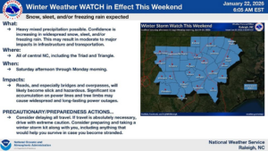
US National Weather Service Raleigh NC | Update: 6:08 a.m.
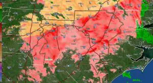
Confidence is increasing that we’ll see a significant winter storm in central NC this weekend. The latest models are trending warmer aloft, which would favor a larger area seeing freezing rain or sleet or a wintry mix of snow/sleet/ice, rather than all snow, but we will continue to monitor to see if this trend continues. Either way, most or all of the forecast area is likely to see wintry precipitation, with potentially significant amounts. In addition, frigid temperatures are expected during and after the storm, lasting into mid week, so any wintry precip will be very slow to melt.
Wednesday, January 21
US National Weather Service Raleigh NC | Update: 3:34 p.m.


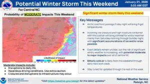
US National Weather Service Raleigh NC | Update: 5:58 a.m.
Confidence is increasing that we’ll see a significant winter storm in central NC this weekend. The latest models are trending warmer aloft, which would favor a larger area seeing freezing rain or sleet or a wintry mix of snow/sleet/ice, rather than all snow, but we will continue to monitor to see if this trend continues. Either way, most or all of the forecast area is likely to see wintry precipitation, with potentially significant amounts. In addition, frigid temperatures are expected during and after the storm, lasting into mid week, so any wintry precip will be very slow to melt.